Your town!
Daily Fruit
Q&A
About
Press
Contact
![]()
Jeep is a registered trademark
of DaimlerChrysler

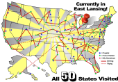
50 States
100+ Households
375 Days
1251 Gallons of gas
29,403 Miles
Some Photos: (Over 2300!) ![]()
Rice the Squirrel
Random Photo
Photo Archive![]()
![]()
![]()
![]()
![]()
![]()
Latest Blogs: (437 total) ![]()
Random Blog
Blog Archive
Jun 30 - Networking and More
Jun 8 - 141 Gas Stations
May 26 - Daily Fruit 2.0
May 8 - 624 Days in a Duffel Bag
Apr 30 - Bickering About Gas Prices
Apr 16 - We Are All Hokies
Mar 25 - A Small World
Feb 25 - Power to the T-Shirt
Feb 11 - Published in JPG Magazine
Feb 11 - 4 Best Bars in the United States

EROS
Monday, Oct 9, 2006 from Sioux Falls, South Dakota
Since I can remember I’ve always loved maps. I remember this huge atlas in our house growing up and just loving to flip through it. The fascination continued as I grew older and I loved looking at aerial photos. And one of the books still on my wish list is that big photography book with 365 photos of Earth from above. The coolest thing these days is what we can access online. Google Earth lets us look at any tiny corner of the world in great detail. Everyone is fascinated seeing what that program can do.
Earth Resources Observation Systems is part of the United States Geographical Survey. They are working on some pretty cool science from the middle of a cornfield. Dave has been working there for ten years. So I got a brief tour. I was amazed by the whole place, though it was a lot of information to take in. it would be great to lean more about the technology.
From my understanding they use satellite imagery of Earth mostly for research purposes. A lot of the images are used during disasters such as forest fires and Hurricane Katrina. They are able to produce these amazing images of, I believe, anywhere in the world. They continually retrieve images of Earth as satellites scan from 300 miles away.
One of the neatest aspects was seeing the computer room. One monitor was showed the actual route the satellite was taking around the Earth and exactly where it was at the time. Another monitor displayed the images as they were coming in second by second. At the time I was watching I believe it was retrieving images over Arizona.
Now that’s just a brief run down from me, who knows nothing about it really. I was silent with fascination while there.
I encourage everyone to check out the site: where you can download all sorts of images.
 Posted: Oct 9, 2006 | 317 words |
  0 Comments