Your town!
Daily Fruit
Q&A
About
Press
Contact
![]()
Jeep is a registered trademark
of DaimlerChrysler

50 States
100+ Households
375 Days
1251 Gallons of gas
29,403 Miles
Some Photos: (Over 2300!) ![]()
Rice the Squirrel
Random Photo
Photo Archive
Latest Blogs: (437 total) ![]()
Random Blog
Blog Archive
Jun 30 - Networking and More
Jun 8 - 141 Gas Stations
May 26 - Daily Fruit 2.0
May 8 - 624 Days in a Duffel Bag
Apr 30 - Bickering About Gas Prices
Apr 16 - We Are All Hokies
Mar 25 - A Small World
Feb 25 - Power to the T-Shirt
Feb 11 - Published in JPG Magazine
Feb 11 - 4 Best Bars in the United States
The Ugliest U.P. Ever!
Saturday, Nov 24, 2007 from Baraga, Michigan
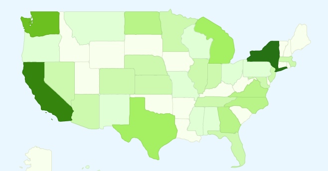
There is no question about it, this is the ugliest and worst representation of I have ever seen of the Upper Peninsula, not to mention of Michigan. C’mon! (found it on google)

 Posted: Nov 24, 2007 | 32 words |
  18 Comments
From Columbus, IN
![]() All I can say is... Wow...
All I can say is... Wow...
From East Lansing, MI
![]() We are no longer a mitten, but the profile of a very sad man... perhaps Bart Simpson?
We are no longer a mitten, but the profile of a very sad man... perhaps Bart Simpson?
From L'Anse across the bay from Baraga, MI
![]() I agree with Stephanie.....sure does look like Bart.....and All we can say is yup, we get the short end of stick when it comes to map making....always.
I agree with Stephanie.....sure does look like Bart.....and All we can say is yup, we get the short end of stick when it comes to map making....always.
From L'Anse, MI
![]() Wow, to me it looks like they forgot us all together. That green blob,?the lakes Michigan and Superior. What a sad state of affairs.
Wow, to me it looks like they forgot us all together. That green blob,?the lakes Michigan and Superior. What a sad state of affairs.
From Moran, MI
![]() That is the most ridiculous map of Michigan I have ever seen. Ummm I am wondering being there is no longer 'the Straits of Mackinac' does that mean I don't have to pay bridge fare anymore?
Most of the people I talk to on-line have no idea there is an Upper Peninsula and a lower Peninsula to Michigan, so I guess it was one of them that drew this map.
That is the most ridiculous map of Michigan I have ever seen. Ummm I am wondering being there is no longer 'the Straits of Mackinac' does that mean I don't have to pay bridge fare anymore?
Most of the people I talk to on-line have no idea there is an Upper Peninsula and a lower Peninsula to Michigan, so I guess it was one of them that drew this map.
From Houghton, MI
![]() Hey, I'm fine with it. they gave us all of lake michigan.
Hey, I'm fine with it. they gave us all of lake michigan.
From Marquette, MI
![]() LOL... that's terrible...
LOL... that's terrible...
From Baraga, MI
![]() To McGuire's comment... HA HA HA HA!!! Good point.
To McGuire's comment... HA HA HA HA!!! Good point.
From Escanaba, MI
![]() Yeah, it's pathetic. The other states are at least recognizable!
So now that we see that there's some YOOPERS here, we need to press Facebook for a UP NETWORK!!!!!!!!!
Yeah, it's pathetic. The other states are at least recognizable!
So now that we see that there's some YOOPERS here, we need to press Facebook for a UP NETWORK!!!!!!!!!
From Marquette, MI
![]() Haha. I agree that it looks ridiculous, but I figured out that it's because they just included all of the territory (land and water) that belongs to Michigan.
They definitely could have just drawn a dotted line though.
Haha. I agree that it looks ridiculous, but I figured out that it's because they just included all of the territory (land and water) that belongs to Michigan.
They definitely could have just drawn a dotted line though.
From THE UP, MI
![]() UMMM that is NOT what michigan looks like. Whoever drew this map must have some serious problems.
UMMM that is NOT what michigan looks like. Whoever drew this map must have some serious problems.
From Unionville, MI
![]() Where did the thumb go? It's pretty bad when one of the most recognizable states from space is so deformed on a map.
Where did the thumb go? It's pretty bad when one of the most recognizable states from space is so deformed on a map.
From Marquette, MI
![]() Hey, at least we are ON the map! I've seen maps where the U.P. is melded with Canada :o
Hey, at least we are ON the map! I've seen maps where the U.P. is melded with Canada :o
From Escanaba, MI
![]() i remember in back in Jr. High we spent all this money to get everyone individual desk maps and the U.P. was in Canada, honestly are geographical experts that stupid?
i remember in back in Jr. High we spent all this money to get everyone individual desk maps and the U.P. was in Canada, honestly are geographical experts that stupid?
From Hermansville, MI
![]() This has got to be the worst map I have ever seen, other than the ones that completely omit us. Wonder what the heck the maker was on, or doing at the time, I mean come on, seriously! Making a not never to use this person's maps in my classroom either!
This has got to be the worst map I have ever seen, other than the ones that completely omit us. Wonder what the heck the maker was on, or doing at the time, I mean come on, seriously! Making a not never to use this person's maps in my classroom either!
From Calumet, MI
![]() This means I won't have to pay taxes anymore! Hurrah.
This means I won't have to pay taxes anymore! Hurrah.
From Sault Ste. Marie, MI
![]() The U.P. is at least shown on this map. Sometimes we're not even included in the US!
The U.P. is at least shown on this map. Sometimes we're not even included in the US!
From Detour/ Drummond, MI
![]() Listen Justin.... this is war.
Listen Justin.... this is war.

